Jaco Island (Portuguese: Ilha de Jaco, Tetum: Illa Jako, Fataluku: Totina or Tontina) is an uninhabited island in East Timor, a country occupying the eastern end of the island of Timor in the Lesser Sunda Islands in Southeast Asia. It lies within the Nino Konis Santana National Park.
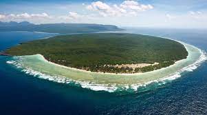
Jaco Island lies just off the eastern end of the island of Timor, part of the Tutuala subdistrict in Lautém District, and is separated from the mainland in front of Valu Beach by a 600 m-wide (660 yd) channel or strait (known as Jaco Strait) navigable by small vessels.
The island, the beach and the channel are sometimes said to be the points where Timor meets the boundary between the Banda Sea (including Wetar Strait) to the north and Timor Sea to the south.[1][2] According to the standard work Limits of Oceans and Seas, 3rd edition (1953), published by the International Hydrographic Organization (IHO), however, the only point where Timor meets those two seas is Tanjong Sewirawa (now known as Cape Cutcha), the eastern extremity of the Timorese mainland. Cape Cutcha is a short distance northwest of the island, and north of the beach.
The island is low-lying, with an area of 11 km2 (4.2 sq mi) and a maximum elevation of about 100 m (330 ft). It is covered mainly by tropical dry forest, fringed by strand vegetation and sandy beaches. There are some low cliffs on the southern coast.